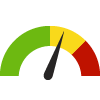
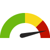
Indicator Gauge Icon Legend
Legend Colors
Red is bad, green is good, blue is not statistically different/neutral.
Compared to Distribution
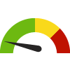 the value is in the best half of communities.
 the value is in the 2nd worst quarter of communities.
 the value is in the worst quarter of communities.
Compared to Target
 meets target;
  does not meet target.
Compared to a Single Value
 lower than the comparison value;
 higher than the comparison value;
 not statistically different from comparison value.
Trend

 non-significant change over time;
 significant change over time;
  no change over time.
Compared to Prior Value
 higher than the previous measurement period;
 lower than the previous measurement period;
 no statistically different change from previous measurement period.
 Significantly different than the overall value
 No significant difference with the overall value
 No data on significance available
Land Covered by Forest
This indicator is archived and is no longer being updated. Click to learn more
This indicator shows the percent of land covered by forest.
Forest is the combination of deciduous forest, evergreen forest, and mixed forest.
Why is this important?
Understanding community characteristics is vital for public health planning, epidemiological studies, and public health emergency preparedness. This indicator is essential to identify a community's most likely hazards, most vulnerable populations, available resources, and ability to respond. Information about the local infrastructure, vulnerabilities, and resources enable public health professionals to quickly establish priorities and take appropriate actions during an emergency or disaster response.

| County | Source | Measurement Period | Percent | |
|---|---|---|---|---|
There are 22 County values. The lowest value is 1.2%, and the highest value is 48.4%.
Half of the values are between 4.5% and 36.9%.
The middle (median) value is 19.1%.
Data Source
- National Environmental Public Health Tracking Network
Maintained By: Conduent Healthy Communities Institute (Methodology)
Filed under: Environmental Health, Physical Determinants of Health